

Guess who’s back, back again …
La Niña’s back—but should you tell a friend?
The answer: It depends on their appetite for cool, wet—and somewhat snowy—weather.
With NOAA officially declaring that La Niña—the climate pattern that results in cooler ocean temperatures in the equatorial Pacific—will return for an encore this winter, chillier-than-normal temperatures are a good bet in Seattle from December through February, along with a boatload of rain.
At first glance, that’s not really saying much, given that this is Seattle—a city infamous for 40-something-degee wintertime rains, punctuated by the occasional soul-sucking 37-degree downpour. But as anyone who has lived here long enough can attest, it’s pretty uncommon for the mercury to dip below the mid-30s when the city’s in the crosshairs of a winter storm. Simply put, the relatively warmer waters of the nearby Pacific Ocean—where most of our storms come from—ensure that the bulk of Seattle’s precipitation falls as rain, rather than snow.
In a La Niña winter, however, our storms tend to come more from the northwest. And this subtle shift in direction can have dramatic impacts on our weather.
La Niña winters: Snowier than average in Seattle
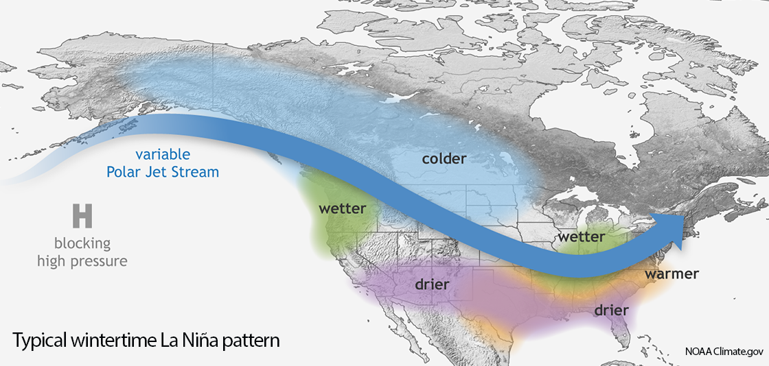
As the image from NOAA illustrates, La Niña winters often feature a sprawling ridge of high pressure well to our west over the Pacific, which blocks storms from approaching Seattle from the west or southwest. Instead, these storms are forced to travel northward over Alaska and the Yukon in order to bypass the mammoth area of high pressure. From there, the storms typically barrel southeastward along the edge of the frigid B.C. interior, picking up considerable cold—and some moisture—as they plunge toward Western Washington.
The end result of all this is that La Niña winters tend to be snowier-than-average in the Seattle area. Case-in-point: Seattle’s average snowfall during a La Niña winter is 7.75 inches (using the 40-year time period from 1981-2021*), compared to an annual average of 6.0 inches over the same 40-year timeframe.
A difference of around 2 inches may not sound that drastic, but that 6.0-inch average is skewed by the big snowfall years of 2008-09 and 2018-19. A better way to estimate La Niña’s impact is to look at the median snowfall during this same period. From 1981-2021, median snowfall in Seattle was 3.8 inches—versus 7.8 inches in winters marked by La Niña conditions. In other words, Seattle can probably expect twice as much snow than usual in a La Niña winter. And in a city often paralyzed by a mere inch of the white stuff, that’s a big deal.
Are second-year La Niña winters even snowier?
For snow-hungry Seattleites, there’s also evidence that suggests that second-year La Niña winters—such as this upcoming one—tend to be snowier than all other La Niña winters (whether first-year or third-year ones).
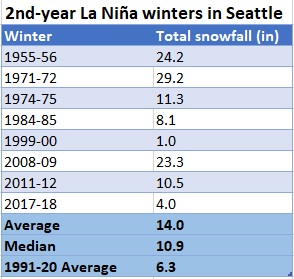
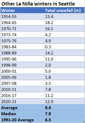
As the charts show, Seattle averages 14.0 inches in second-year La Niña winters, versus 8.4 inches in all other La Niña winters. The difference is less pronounced when it comes to median snowfall (10.9 inches versus 7.8 inches), but still noteworthy. Importantly, the sample size here is relatively small, so don’t take this as gospel. But if you’re a snow fan, it’s certainly encouraging to see.
Our winter snowfall forecast: 8 inches
Based on all the information above, plus a few hunches—for whatever that’s worth!—we predict 8 inches of snow in Seattle (as measured at Sea-Tac Airport) this winter. This is on par with the average snowfall for a La Niña year, but less than what’s typically seen during a second-year La Niña. It’s also a lower amount than the 12.9 inches that coated the ground in Seattle last winter (most of which came during February’s blockbuster snowstorm).
So, why only 8 inches? Shouldn’t we be calling for at least a foot, given that we’re staring down the barrel of a second-year La Niña? While the above numbers certainly argue as much, another stat jumped out at me as I was combing through the yearly snowfall totals—the number of times Seattle has experienced back-to-back winters with double-digit (10 inches or more) snowfall. Since 1973, it’s only happened once—in the winters of 1995-96 (11.0 inches) and 1996-97 (Sea-Tac didn’t measure snow that winter, but rest assured, Seattle received well over 10 inches). Maybe it’s the been-burned-too-many-times-before snow pessimist in me, but I have a hard time seeing the 2020-21/2021-22 stretch becoming the second such occasion.
Then again, Mother Nature has a way of making fools out of all of us, so perhaps this will end up being the case.
As a diehard snow enthusiast, I sure hope so.
*Data from 1981-1996 and from 2004-2021 is from official NWS records at Sea-Tac Airport. From 1996-2004, Sea-Tac Airport did not measure snowfall. The snowfall numbers used for the winters during this timeframe are best-guess estimates based on other weather observations from the time, as well as the author’s personal memories and those of other Seattle-area weather enthusiasts.


Great article, I found it extremely informative and interesting.
a ski bums favorite kind of article