

It’s the snowiest start to a Seattle winter in nearly four decades.
But does that mean an extra-snowy winter, perhaps to the tune of 2008-09, is in store for 2022-23?
The answer: Probably not, but if history is any guide, the odds are pretty good that Seattle will receive additional snowfall before spring. But whether that’s just a measly inch or another foot is difficult to say. Let’s take a look at the data to see why.
Does a snowy start make for a snowy winter?
With 4.4 inches of snow through Dec. 3, this is the 6th-snowiest start to a winter season in Seattle since record-keeping began at Sea-Tac Airport in 1945. (Yes, I know, it’s not technically winter yet, but snowfall in November and early December still counts!) For those of you who hail from much snowier climes, this 4.4-inch number probably seems pretty lame, but for a city that only averages 6.3 inches during the course of an entire winter, it’s actually very impressive.
So, what does the data suggest about how much snow Seattle could receive the rest of this winter? Take a look at the chart below, which shows how the top 11 winters (not counting this year) with the most snow through Dec. 3 fared overall.
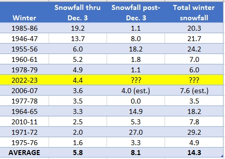
Interestingly, all but one winter went on to record more snow after early December. What’s more, on average, approximately 8 inches of additional snow fell between early December and the end of winter. That’s got to be a good sign, right? Well … not exactly. While at first glance this does seem to indicate that winters that start off snowy end up snowy, the devil is in the details—and a closer look at the chart shows the results to be annoyingly inconclusive.
Snow fans, be warned: The big letdown of 1977-78
Case-in-point: In five of the 11 years with snowy starts, Seattle received less snow the rest of the winter than it did in November/early December. The king of all letdowns for snow lovers was the winter of 1977-78, where 3.5 inches fell between Nov. 17-23. The following day, Nov. 24, was Thanksgiving, and it’s a safe bet that Seattle snow fans woke up that day extra thankful for their early-season blanket of white. Alas, they must not have thanked Mother Nature enough, because no additional snow fell in the city again for the rest of the winter. Ouch!
Snow fans, take heart: The winters of 1955-56 & 1964-65
On the other side of the coin, in six of the 11 years with snowy starts, Seattle received more snow the rest of the winter than it did in the same November/early December timeframe. This was especially the case in both the winter of 1955-56—which logged an additional 18 inches after a pair of mid-November snowstorms—and the winter of 1964-65, where a Thanksgiving Day snowfall was followed by nearly 15 more inches of additional snow the rest of the winter. And the granddaddy of them all, 1971-72, saw a staggering 27 inches of snow fall after first receiving 2 inches of snow in late October.
More recently, the winter of 2010-11 saw 5-plus inches accumulate from December through February, after 2.5 inches fell in the infamous flash freeze of Nov. 22, 2010, that crippled the city. Interestingly enough, each of these four winters was a La Niña winter—although neither was a triple-drip La Niña, like this winter.
However, the winter of 1975-76, which ranks #12 on the snowy-start chart, was a third-year La Niña. Perhaps coincidentally—or perhaps not—that winter started off somewhat similar to this one, with back-to-back half-inch snowfalls at the tail end of November. However, only 3.3 inches of snow was recorded the rest of the way, with 2.6 inches falling in mid-December 1975 and miniscule amounts in late February/early March of 1976.
The Seattle Weather Blog’s crystal ball predicts …
In short, the data suggests it’s a flip of a coin as to whether Seattle is headed for an extra-snowy winter—or will merely pick up a scant few inches between now and spring. But, that’s not what you’re here for! You want a prediction—and you deserve it after slogging through this.
So, I’ll go on record as saying Seattle will receive at least 6 more inches of snow this winter, which would officially make the winter of 2022-23 snowier-than-average in the weather books. And if this prediction doesn’t pan out?
I’ll be wiping plenty of egg off my face come springtime.


I don’t see 2019 in your list of snowiest years. Is it a discrepancy between SeaTac and Seattle numbers? Because here in Bellevue, February 2019 was by far the snowiest year I’ve seen. I kind of remember some snow in ’07 and ’11 but it was ’19 that will stick with me forever.
Your blog seems to support my memory:
https://seattleweatherblog.com/snow/february-2019-seattles-snowiest-month-50-years/
This is a list of snowiest starts to a winter–not snowiest winters overall. 2018-19 was a very snowy winter–but not until Feb. 3!