

The Sea-Tac temperature saga continues.
Under a broad ridge of high pressure, temperatures climbed into the mid-80s yesterday across central Puget Sound, with Boeing Field in south Seattle clocking in at 85 degrees, while the University of Washington hit 86. But at Sea-Tac Airport, the official weather-reporting site for the city, the mercury shot up to 89 degrees just before 4 pm—a reading inconsistent not only with the region’s other main weather stations, but with smaller, nearby ones as well.
Take, for instance, two of the closest weather stations to Sea-Tac. UW research meteorologist (and past state climatologist) Mark Albright noted that the high temperature at the nearby Angle Lake Haven weather station (SEATA6) was only 85.3 degrees. This station is located roughly 10 blocks southeast of Sea-Tac. Similarly, Albright pointed out that a station in Des Moines close to the southwest corner of the airport—SEATT4—registered a high of just 84.2 degrees. All told, Sea-Tac appears to have been running 4 to 5 degrees warmer than its surroundings yesterday.
How many times has Seattle really reached 90 degrees this year?
As we’ve noted before (along with Albright and University of Washington Professor Cliff Mass), there’s been a slew of recent suspect temperature readings at Sea-Tac on hot summer days. For instance, during July, the temperature at the airport reached or exceeded 90 degrees on seven occasions—more than double the number of times the aforementioned Angle Lake and Des Moines stations did. Furthermore, Boeing Field, which typically runs slightly warmer than Sea-Tac, only hit 90 degrees three times during the month.
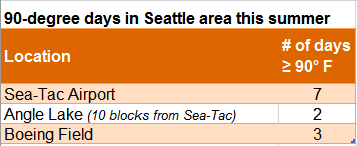
But, because the Sea-Tac numbers are what’s used for official Seattle weather data, the record will show that the city logged seven 90-degree days last month—tying 1958 for the second-most in any month, after July 2015. The evidence suggests otherwise.
What’s behind the suspect readings?
While it’s inconclusive at this point what the exact problem could be at Sea-Tac, one theory is that the warmer readings are due to north or northwesterly winds blowing toward the sensor. Because the temperature sensor is located near the southern end of two of the three runways, winds from this direction will blow over a longer stretch of hot pavement before reaching the sensor. On a hot summer afternoon (which we’ve had many of recently), this problem will naturally be made worse. University of Washington doctoral candidate Joe Zagrodnik, pursuing his Ph.D. in atmospheric sciences, sheds some light on this below:
For some reason, this bias has been especially bad this year (see plot)–you can see 3-5 F differences have been quite common–and Seatac has run warm even with southerly winds and temps in the 60s. But it has been inconsistent, making it difficult to diagnose. pic.twitter.com/SHiVgUM7X1
— Joe Zagrodnik (@joejoezz) August 3, 2018
Another likely cause is a faulty temperature sensor, which could be exacerbated by a broken fan within the sensor unit. Or, the issue could be a combination of the two. In either case, it appears that problems with Seattle’s official weather station are continuing—putting the integrity of the city’s climate record in jeopardy.
Author’s note: The National Weather Service inspected the sensor on July 26 and says it is working fine.


Hello from the east coast. I came across your blog and comments with regard to Seattle’s weather station temperatures. When you have a moment, perhaps take a peak at the weather blog I participate in – http://www.woodshill.net/ It’s creator has comments nearly identical to yours with regard to Logan Airport’s temperatures.