

Is Seattle’s hottest day in over a decade just around the corner?
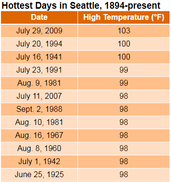
Ever since the city soared to 103 degrees at the height of an oppressive July 2009 heat wave, Seattle has managed to dodge any further extreme daily heat, with the high temperature at Sea-Tac Airport never exceeding 96 degrees in the 11 years since.
The past decade: Lots of persistent heat, but no extreme high temperatures
That’s not to say the past decade hasn’t been very hot overall, of course. In fact, summers during the 2010s were often notoriously—and uncomfortably—hot, with six of the 10 warmest months in Seattle history occurring since 2013 alone. This includes July 2015, which bested August 1967 as the hottest month in city history, with an average temperature of 71.2 degrees.
Yet even in those persistently stifling months, which often featured multiple bouts with 90 degrees, high temperatures only peaked in the mid-90s on the warmest days—hot, but not hot enough to make the top-ten list of warmest days in Seattle history.
If the latest trends in the weather models hold true, however, this list may have a new addition by the end of the weekend.
Hot winds from the east arrive this weekend
After another day-and-a-half of pleasant weather, a massive ridge of high pressure located over the desert Southwest is expected to bulge northward as the weekend gets underway, propelling temperatures into the mid-80s by Saturday. Even more importantly, a warm area of low pressure at the surface—known in weather-speak as a thermal trough—is expected to slide northward from Oregon as the day progresses. This will have major implications for high temperatures on Sunday.
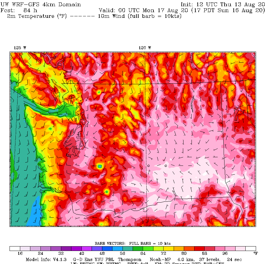
As the area of warm low pressure treks up our coastline, the winds will flip to an easterly direction, dragging hot air from Eastern Washington over the Cascades and into Puget Sound. This will super-charge the already-warm air mass in place, with temperatures skyrocketing into the 90s by Sunday afternoon. This is a classic set-up for extreme heat in the Seattle metro, and especially for Sea-Tac Airport, which is prone to warm easterly—or Cascadia—winds in the summertime.
98 degrees possible on Sunday
So, just how hot could it get? Most places around the Sound will likely top out in the mid- to upper-90s, as indicated by the latest University of Washington model forecast. Sea-Tac is likely to be one of the warmest spots overall, with a high temperature of 97 or 98 degrees looking increasingly possible. A high of 97 would make Sunday the hottest day since July 29, 2009, whereas a high of 98 degrees would earn it a spot on the fabled top-ten warmest days list.
Either way, Sunday is shaping up to be a real scorcher—the likes of which we haven’t seen in years. We’ll be tracking the potentially historic heat closely in the days to come. Be sure to follow along with us on Twitter for real-time updates.


