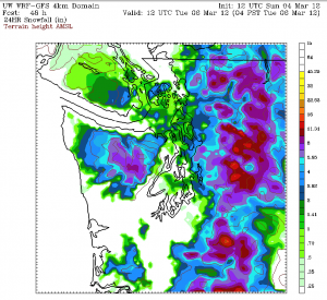
Get ready for another bout of snow—one that could affect the entire Seattle metro area tomorrow afternoon and evening.
After several days of waffling over how low the snow level could fall Monday afternoon, forecast models this morning have come to a somewhat shocking—and snowy—consensus. Their prediction? Snow levels will plummet dramatically—from several thousand feet all the way to sea level—by the noon hour on Monday. The University of Washington’s WRF model goes so far to suggest that temperatures will drop nearly ten degrees in a three-hour timespan tomorrow morning, as a very strong cold front barrels through the region. In other words, a 45-degree rain at 7 a.m. will become a 35-degree rain/snow mix by 10 a.m. Such a nosedive in temperatures is typical east of the Rockies, but in Seattle? In March?

What’s more, all models indicate that a Puget Sound Convergence Zone will form immediately in the wake of the cold front, dragging the snow level down to the surface amidst moderate-to-heavy precipitation. The Zone is likely to form around the Everett area in the early afternoon and push south during the evening hours, dumping a heavy, wet snow as it moves over the metro area. Temperatures during this time will range from about 32 to 36 degrees, meaning that accumulating snowfall is a possibility.
In fact, the most reliable model out there—the aforementioned WRF from the UW—predicts that two to four inches of snow will fall from north of the Ship Canal Bridge up to Shoreline. North of Shoreline, snow amounts exceeding SIX inches are possible. To the east of Lake Washington, up to four inches of snow is possible, with the greatest amounts falling on elevated areas away from the water. If the WRF is to be believed, then even Seattle proper could see an inch of the white stuff, with amounts closing in on two inches as you get further south towards Sea-Tac Airport. Talk about exciting.
The one major caveat to all this? Warm surface temperatures. After two days of temperatures in the 50s, roadways across the region are quite warm—meaning that it’ll take quite some time for temperatures on paved surfaces to fall into the 30s. Because of this, accumulation on roads (especially in the immediate Seattle area) is unlikely, at least for several hours. Rather, the snow is most likely to stick to grassy and dirt surfaces, where temperatures will cool much faster.
In any case, tomorrow has the potential to be quite white around here—a true rarity for Puget Sound this time of year. Get that winter jacket ready.


