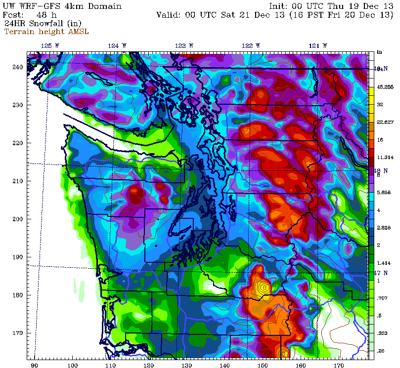
Thursday night update, 8:30 pm: The latest high-resolution weather model from the UW is unchanged from last night. 2 to 4 inches of snow still looks likely for most of the Seattle area tomorrow morning. Lowest amounts will be in downtown Seattle, highest amounts will be east of Lake Washington and north of Seattle.
***
It’s been nearly two years since Seattle last picked up an inch or more of snow.
That all ends Friday.
A soggy system barreling in from the Pacific will collide with a mass of cold, dry air over Puget Sound in less than 36 hours’ time, unleashing an early morning world of white across the metro area.
Let the snow countdown begin.
Between now and late Thursday night, it’ll be the calm before the storm, with partly cloudy skies giving way to full-on sunshine by mid-morning. Chilly winds out of the north, however, will limit highs to just the upper 30s, setting the stage for what’s to come.
The clouds gradually thicken from the northwest tomorrow night as Friday’s snowmaker—a warm front lurking off the coast of Vancouver Island—approaches. By 10 p.m., flurries should start cropping up from the Olympic Peninsula to the San Juans.

The first flakes of the season trickle into the Seattle area just after midnight, with a widespread light snow gracing the city by 4 a.m. Current weather models predict a half-inch to inch of the white stuff falling during this time frame. And then, just around sunrise, things get even more interesting.
The heart of the warm front plows through the city from 4 to 7 a.m., triggering a band of moderate snowfall up and down the I-5 corridor from Federal Way to Marysville. Amounts look to be the heaviest the further east you go, with the latest high-resolution weather models from the University of Washington painting a wide swath of 2 to 3 inches over the Eastside—right smack-dab during the Friday morning commute. Even Seattle proper, though, should get in on the fun—with an additional 1 to 2 inches likely during this three-hour period.
The snow begins transitioning to rain by mid-morning as warm, blustery winds out of the south kick in, chipping away at the arctic air in place. Temperatures, which will hover around or just above the freezing mark as the bulk of the snow falls, should inch into the mid and upper 30s as the morning progresses. By early Friday afternoon, the mercury should be touching 40 degrees across most of Western Washington—save for the Bellingham area, where the cold air will hold on a little longer.
All told, by the time the switchover to rain occurs, most of the metro area will likely have collected 2 to 4 inches of snow—with the lowest totals in and around downtown Seattle, and the highest amounts east of 405. At Sea-Tac Airport, where Seattle’s official weather records are kept, close to 3 inches is expected before the melting begins—giving us our snowiest day since January 2012.
And a true taste of winter almost two years in the making.


Will West Seattle get some snow?
Latest models suggest 1 or 2 inches there before rain kicks in mid-morning. I’d go with 1 inch, though–thanks to some snow shadowing from Olympics.
Will Bellingham get some fluff?
Yep, you should be good for at least an inch, maybe two. The cold air will hold on longer for you as well–might not change over to all rain until mid-afternoon.