It’s been everything from abnormally warm to unusually dry to just plain wet over the past four years, but it sure hasn’t been snowy.
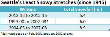
In fact, Seattle is now suffering through one of the least snowy stretches in its history.
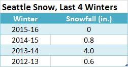
A meager 5.4 inches of snow has fallen on the city the past four winters combined—a half-inch less than we average in one winter alone. What’s more, three-quarters of that came two years ago, when a minor pre-Christmas snowfall teamed up with the largest February snowstorm of the decade to make for a 4-inch total.
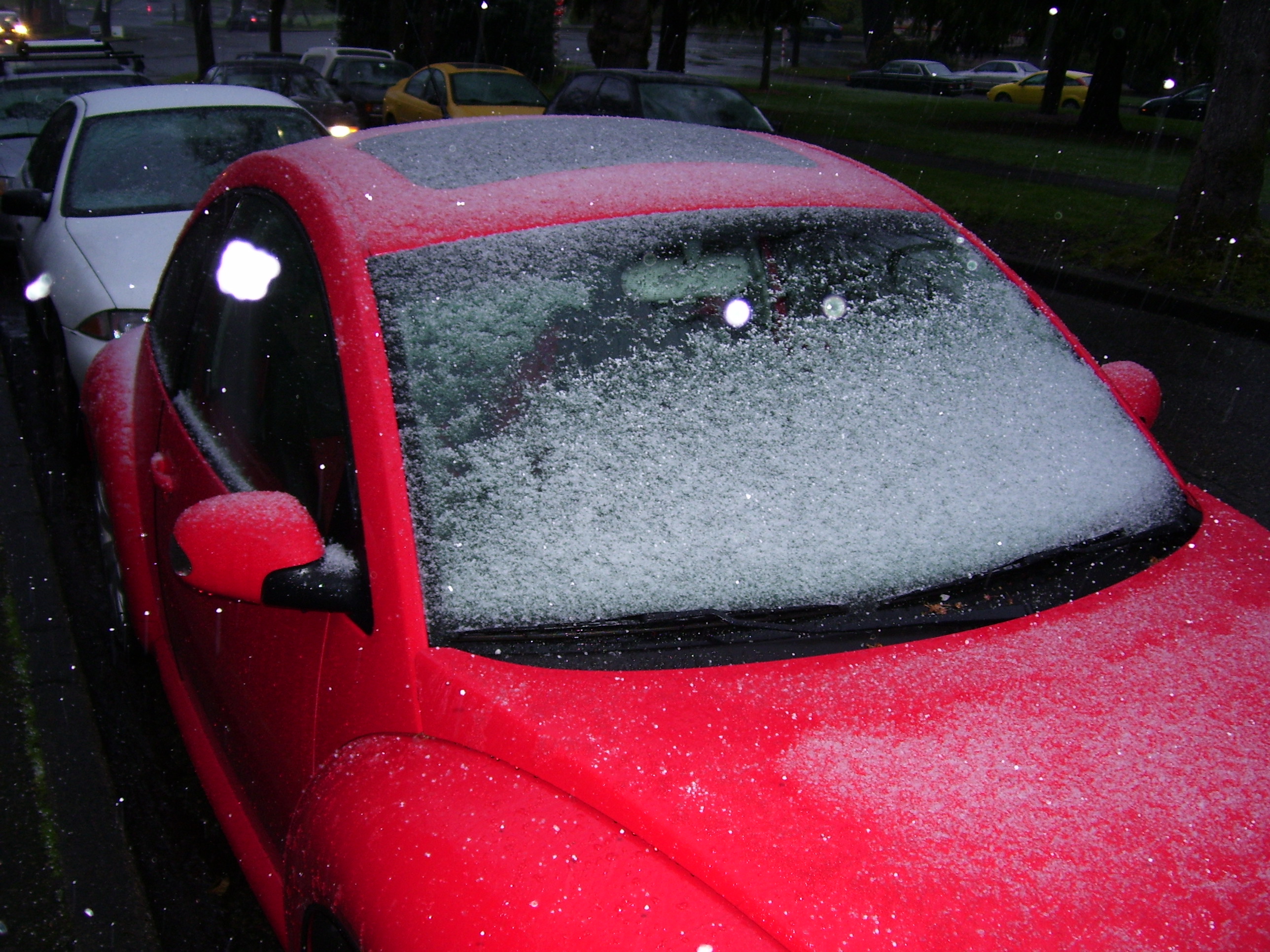
Since then, Seattle has yet to record even an inch of the white stuff—with the 0.8 inches that stuck to the ground on Nov. 29, 2014 our only accumulating snowfall of the last two years. The best the city saw this winter? A dusting just after New Year’s—which failed to add up to anything measurable at Sea-Tac Airport (the city’s official weather-monitoring site).
This is certainly not the first time Seattle has gotten skunked in the snowfall department. El Nino winters are notorious for depriving the city of snowflakes, as happened most recently in 2009-10 and 2002-03. What’s unusual is that we’d already endured three consecutive under-performing winters prior to this one. Taken together, our four-year stretch of dismal snowfall appears to be the worst on record in the history of Sea-Tac.
Sea-Tac’s snow history
Record-keeping began at Sea-Tac in 1945—shortly before some of Seattle’s biggest snows on record made their presence known. Throughout much of the 1950s and ’60s, several blockbuster snowstorms took aim at the city, leading to extreme totals such as the 67.5 inches that fell in 1968-69, and the 63.6 inches in 1949-50. Those mega-years aside, Seattle typically managed at least 7 inches in most winters up until the mid-’70s, when lower snowfall totals became more common.
Still, as this first graph shows, no extended period of lackluster snow conditions was observed up through the winter of 1995-96. Shortly thereafter, for head-scratching reasons, the National Weather Service abruptly stopped recording snowfall at the airport.
From the winter of 1996-97 through the winter of 2003-04—a span of eight winters—snow measurements went dark at Sea-Tac Airport. The timing couldn’t have been worse. Massive snowstorms—which likely would have cracked the airport’s top-10 list—buried the Seattle area in December 1996, with the National Weather Service’s Sand Point office in North Seattle recording 17.9 inches of snow that month.
The years that followed were mostly snow duds. With no precise data from Sea-Tac, it’s impossible to calculate exactly how much snow fell from the late 1990s through the early 2000s. Luckily, hourly observations from a Jan. 27, 2002 event (where 1 inch of snow likely accumulated) and a fortunate snow depth reading from a big storm on Feb. 15-16, 2001 paint a pretty good picture. The stretch from 1999-00 through 2002-03 produced roughly 6.0 inches of snow—pathetic by historical standards, but not quite as lame as the past four years. Despite the missing data, it’s very likely that 2012-2016 is Seattle’s least snowy stretch of the modern era.
What about before Sea-Tac?
Prior to 1945, official weather records for the city were kept at the Federal Building in downtown Seattle—where snowfall was measured beginning in 1894. Only once in 50 years did the city endure a quieter period of snow. From 1938-39 to 1941-42, just 3.4 inches of snow was measured—setting the all-time mark for snow futility in the city.
Even 2012-2016 can’t quite stack up to this—perhaps offering some relief to worried residents, who can now comfort themselves knowing that it truly was worse in the olden days … but only once. With the city’s overall snowfall in decline since the mid-’70s, more frequent stretches with little to no snow are a good bet in the decades ahead.
In other words, fellow snow-starved Seattleites, prepare to be hungry for many winters to come.

