Old Man Winter wants to be your valentine, Seattle.
And to prove it, he’s bent on ensuring there’s more than just love in the air by this weekend.
How does a cascade of giant, swirling snowflakes sound?
Love it or not, ready or not, a pair of back-to-back snowstorms appears increasingly likely for the Seattle area later this week.
The action gets going in earnest Thursday morning, as an area of low pressure spins toward the mouth of the Columbia River, rotating bands of moisture up into Puget Sound. With arctic air firmly entrenched over the region by then—thanks to a steady stream of cold air spilling southward from the Fraser River Valley—any precipitation that falls will easily fall in the form of snow. And fall it will.
By Thursday afternoon, light to moderate snow is likely from Olympia up through Tacoma as the low plods eastward, coating the southern half of our state in a fresh blanket of white. The snow is slated to arrive in Seattle by the early evening, continuing on and off through much of Thursday night before easing early Friday morning.

How much snow is likely from Thursday’s storm?
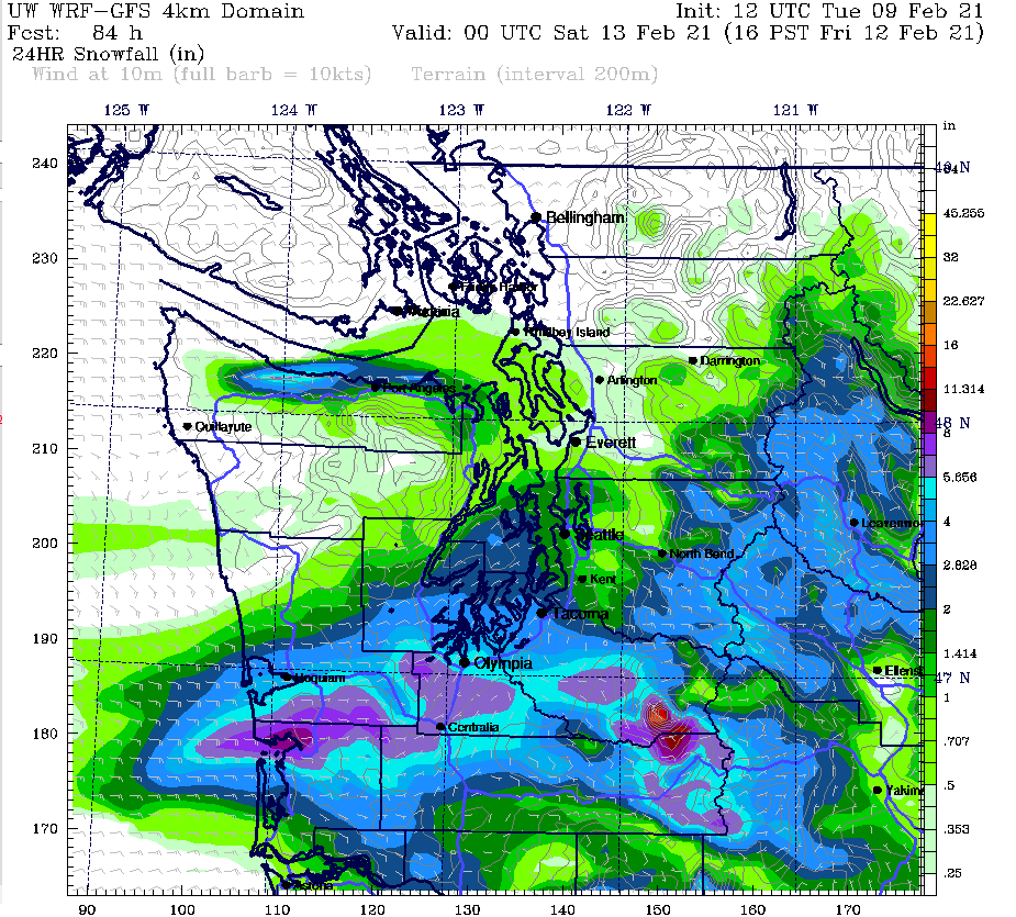
At this time, 4 to 6 inches of snow looks like a good bet from Olympia to Tacoma by Friday morning, with pockets of even heavier accumulation possible. Current models predict about 2 or 3 inches in Seattle, with amounts decreasing further north over Snohomish County, where only 1 or 2 inches may fall. But, as anyone who’s lived in Seattle for at least one winter knows, a couple inches of snow is enough to cause some serious disruptions in the area. A few inches more than that can easily bring the region to its knees.
Which brings us to storm number two …
The Saturday morning storm: The big kahuna?
After a relative break in the weather by midday Friday—skies should clear a bit for a much calmer afternoon and evening than Thursday—another system looks to take aim at the region overnight into Saturday. This storm is likely to pack more of a punch in the immediate Seattle area, with several inches of accumulating snow possible.
In fact, at first blush—pun intended—it appears that the city could see 4 to 6 inches of new snow by late Saturday morning. Note that this would be on top of whatever snow falls from Thursday’s storm, meaning that parts of the metro area could be approaching 10 inches by midday Saturday. It goes without saying that such a significant amount of snow would likely have severe impacts on the metro area. While it’s still too early to tell if such a forecast will pan out, it’s a good idea to start re-thinking any travel plans you may have for later this week.
About those temperatures …
In addition to the snow, it’ll also be downright cold from Thursday through the entirety of the upcoming holiday weekend, with highs struggling to reach the mid 30s, and overnight lows plunging into the mid 20s. To put this in perspective, our normal high temperature for mid-February is 50 degrees, and our normal low is 37. In other words, our daytime high temperatures will likely be chillier than our normal overnight lows. Febrrrrrrrrruary, indeed.
Current weather models also hint at additional snow chances beyond Saturday, including another—wait for it—flirtation with the white stuff as soon as Sunday.
That day, of course, happens to be Valentine’s Day, which makes Old Man Winter’s message to Seattle all the more clear:
Be mine.


[…] some local weather experts and aficionados are predicting a massive snowpocalypse, the weather service says its “confidence is not very […]