
***SUNDAY PM UPDATE: 3.5″ of snow fell at Sea-Tac Airport this evening, bringing February’s snowfall total to 14.1″. This is now the snowiest month in Seattle in 33 years (since November 1985).
It’s also the snowiest February on record at Sea-Tac Airport (where records have been kept since 1945), and the third-snowiest February overall in Seattle. Prior to Sea-Tac, weather records for the city were maintained at the Federal Building in downtown Seattle, from 1891-1945. Only February 1916 (35.4″) and February 1923 (17.4″) were snowier.***
Another day, another Puget Sound snowfall.
The third snow event in the past week is unfolding over Western Washington this afternoon as a weak area of low pressure swings through, promising to drop another 1 to 4 inches of snow throughout the metro area.
February 2019: Soon to be our snowiest month in 33 years?
At Sea-Tac Airport, which serves as the city’s official weather-reporting station, another 2 inches of accumulation is likely by 10 p.m. tonight—which would bump Seattle’s February snowfall tally up to around 12 inches (it currently sits at 10.6 inches). That would put the city on the verge of surpassing December 2008—when 13.9 inches of snow fell—for the snowiest month in Seattle since November of 1985 (when 17.5 inches fell).
Snowstorm #4—arriving Monday night—will likely do the trick.
Heavy snow, potential ice storm Monday night
Following tonight’s light snow, a stronger, juicier area of low pressure will swing in from the Pacific. Moisture from the system will clash immediately with the very cold air already in place, touching off a round of moderate to heavy snow by Monday afternoon.
Snow is likely to overtake the Seattle metro by around 3 or 4 p.m. tomorrow, with approximately 4 to 8 inches falling from downtown Seattle northward through Everett Monday evening. Further south, toward Tacoma and Olympia, snow totals will probably be more in the 2-to-4-inch range as warmer air starts invading the region. (Snow will likely start in the South Sound between 1 and 3 p.m.)
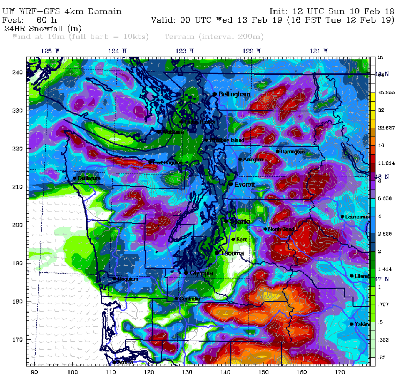
With the area of low pressure tracking right over the metro area, the forecast becomes incredibly tricky Monday night into early Tuesday morning. To the south of wherever the low winds up, warmer air will flood in from above, leading to a rain/snow mix or freezing rain, before changing over completely to rain very early Tuesday. To the north of the low, snow may continue well into Tuesday morning before switching to rain.
Snow or ice? It depends where the low goes
So, where exactly will the low go? Our best guess at this time is somewhere between Seattle and Everett, which means an increasing threat of an ice storm Monday night south of the I-90 corridor (south of a line from downtown Seattle through Bellevue and Issaquah). From I-90 northward, heavy snow appears likely until sometime late Monday night/early Tuesday.
We can’t stress enough how highly sensitive this forecast is to slight changes in the track of the low—if the low takes a more southern route than expected, 8 inches of snow could fall from Tacoma northward. A more northern track (say, over Mount Vernon) would mean much less snow—and more of a rain/snow mix—for the metro area.
Warming into the 40s by Tuesday afternoon
In either case, temperatures are likely to creep up into the low 40s by Tuesday afternoon, helping melt some of the snowpack—but also making for a giant slushy mess on roadways and streets throughout the Sound. We then look to catch a break Wednesday into Thursday, with dry conditions and high temperatures flirting with 45 degrees in the afternoon.
Until then, it’s going to be quite the wild ride. Hang on, Seattle, as February 2019 appears intent on cementing its place in Northwest weather lore.


via GIPHY