We’ve danced this dance before, huh?
An early-morning Puget Sound Convergence Zone has brought snow showers, along with spotty accumulations, to areas along the King-Snohomish County line. Since 7 a.m. this morning, snow has fallen off and on in North Seattle, Shoreline, Lynnwood and Bothell—the same cities that see the flakes time and time again, while the rest of the region experiences a cold rain. (Yes, Lynnwood—we’re jealous. How would you like to wake up to a 37-degree rain?)

As we head into the afternoon, the Convergence Zone will shift further east into the Cascades, allowing temperatures to rise into the lower 40s. This should bring an end to any lingering wintry precipitation in the aforementioned Puget Sound snow belt. For the rest of the day, scattered light rain showers are possible just about anywhere in the Seattle-Tacoma-Everett area—decreasing as evening sets it. Cooler air will begin filtering into the Sound tonight, dropping temperatures into the mid-30s—and setting the stage for a chance of snow.
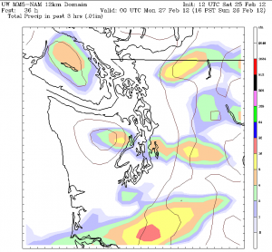
Enter Sunday. Both high-resolution models from the University of Washington agree that a Convergence Zone of sorts—spun up along an arctic frontal boundary—will form around the Everett area in the early morning. The Zone is forecast to dump an inch or two of wet snow over southern Snohomish County before moving south towards the noon hour. At this point, the models begin to diverge—with one model forecasting the Zone fizzling out as it reaches Seattle, while the other keeps it alive and kicking as it plows through the Seattle-Bellevue corridor.
If the latter model (the NAM) is correct, snow showers will fall to near sea level in and around Seattle, with accumulations of up to an inch possible. Par the course, Downtown Seattle would only see a dusting at best under this scenario—but higher areas of the city, like Capitol Hill, Phinney Ridge and Queen Anne, could easily pick up a slushy inch or so. Unfortunately (buzzkill alert), once the Convergence Zone passes through—assuming it makes it to Seattle—skies will begin to clear, melting any snow that has fallen.
The good news? After a dry and cold Monday, forecast models indicate that we’ll flirt with low-elevation snow again on Tuesday and Thursday.
In other words, get ready to dance this dance once more.


