

***FRIDAY AM UPDATE: We’ve increased our snow forecast from 3-5 inches to 4-8 inches. Highest amounts are likely to be in the immediate Seattle metro area, where up to 8 inches could fall. The worst of the snow is expected between 3 and 7 p.m. tonight. Road conditions will deteriorate rapidly after 3 p.m., and travel will become hazardous throughout the entire region. Follow us on Twitter for continuous updates as the storm unfolds.***
The sequel never lives up to the original, it’s widely proclaimed.
Friday’s impending snowstorm may have a thing or two to say about that.
The second snow event of the week is primed to plaster Puget Sound as the weekend gets underway, threatening to wallop the Seattle metro with up to 8 inches of snow and a blast of frigid winds. Fresh off the heels of an overachieving Sunday-into-Monday storm that unloaded 2 to 5 inches of snow throughout the city (with amounts approaching 10 inches in Snohomish County and throughout the Eastside), round 2 is likely to pack just as nasty of a punch.
Friday afternoon: Snow begins in the Seattle metro
The first jab at the region begins Friday morning, as an area of low pressure descends from Vancouver Island, zigzagging southeast on a beeline for the Columbia River. As the low dives off our coastline, it’ll help drag arctic air from the chilly Canadian interior into Western Washington, unleashing a blast of icy winds that will smack Bellingham first before spreading down the I-5 corridor. For Whatcom County, northeasterly winds could gust up to 55 mph throughout much of the day on Friday.
As the storm closes in on a landfall near Astoria, moisture will overtake the region from the west, likely reaching the greater Seattle-Everett-Tacoma area by 3 pm. With cold air already in place, and another shot arriving from the north, the precipitation is likely to start out as snow for most of the area—save perhaps south of downtown Seattle, where rain could mix in with snowflakes for a few hours before turning over to just plain snow.
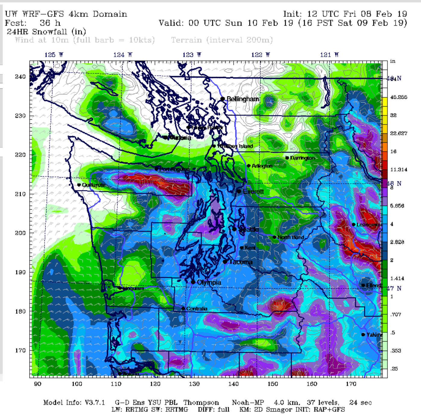
Heavy snow possible Friday night
By late Friday night, moderate—and occasionally heavy—snow is likely over all of Puget Sound. Current models indicate a threat of 4 to 8 inches of snow, especially from Seattle north into Snohomish County. The snow is likely to continue well into Saturday morning, with gusty northeasterly winds arriving around then as well. Current models hint at speeds up to 40 mph around noon on Saturday, which could lead to isolated power outages, especially since the wind will be from a more unusual direction.
Dangerous travel conditions Friday night through Saturday morning
It goes without saying that the impacts from this storm will likely be wide-ranging, from more snow-packed roads and icy side-streets to downed branches, trees and perhaps even power lines (especially north of the metro area). Similar to Monday morning, travel will become hazardous during the height of the storm—and probably remain unsafe well into midday Saturday.
Fortunately, the region looks to catch a breather Saturday night into Sunday, before another potential whopper of a snowstorm takes aim at us on Monday. But that’s another blog post for another time. For now, plan on a significant, high-impact winter snowstorm Friday into Saturday that will likely rival the early-week storm.
After all, every now and then, the sequel holds its own.
Editor’s note: This post was updated on Feb. 8, 2019, to reflect our forecast for higher snowfall totals.


