So this is what it feels like to live life on the edge.
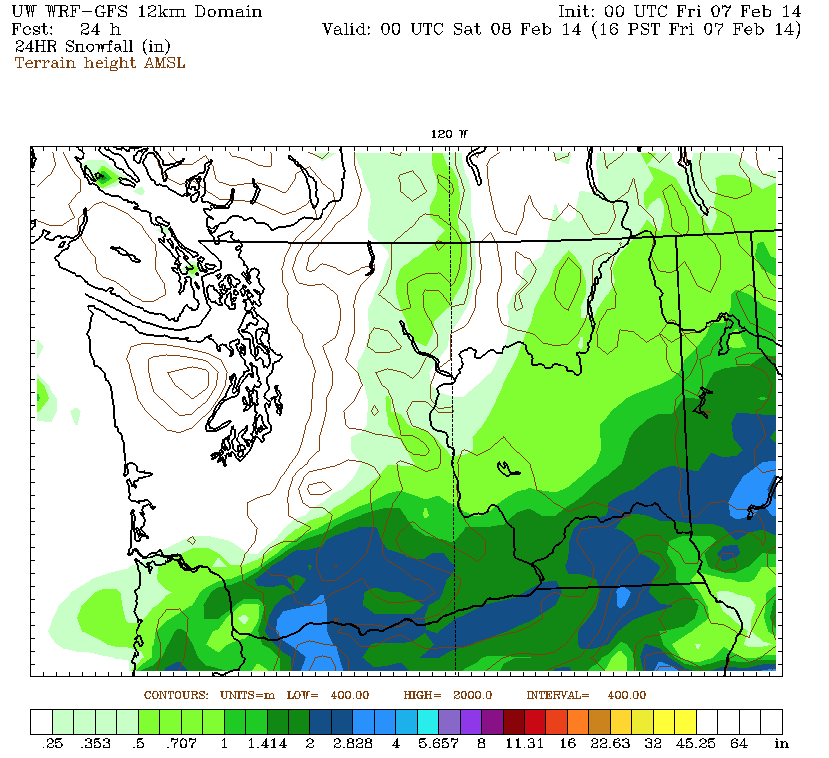
The outermost bands of a snowstorm battering the Portland area are expected to creep as far north as King County tonight, putting the Seattle metro on the very northern fringe of the flakes.
So close—but close enough to matter?
The answer: probably not.
The latest forecast models keep all meaningful snow accumulations south of Olympia, with just a dusting at best expected for Seattle and surrounding suburbs later this evening. With a very dry air mass in place, lingering moisture spreading north from the Oregon storm will have a tough time reaching the ground—evaporating before it does in most cases.
Still, some flurries are likely across the region as we head deeper into the night and the air mass moistens up a little more. With temperatures solidly below freezing—the mercury at Sea-Tac Airport hasn’t reached 32 degrees in 48 hours—anything that does fall will stick to the roads, so take it easy if the flakes start coming down.

The flurries shut off overnight, leaving us dry and cold for Friday morning. Once again, low temperatures will be downright frigid for early February, dropping to the mid or lower 20s. Cloudy skies in Seattle will probably prevent us from tying the record low for the day of 20 degrees (set in 1989), but it’ll be a nippy start nonetheless.
Echoing the cold weather of the past two days, temperatures will only peak in the low 30s tomorrow—20 degrees below average for this time of year. Not only is this rare for February, it’s uncommon in Seattle overall—happening only every other year or so. In fact, until yesterday, Seattle hadn’t recorded a sub-freezing high since Jan. 19, 2012. What’s more, today’s peak reading at Sea-Tac of just 29 degrees was the first time the high temperature didn’t get out of the 20s since November 2010.
After a chilly, gray Friday afternoon, another storm system slides into Oregon tomorrow night, dumping more powder on Portland and threatening places further north (like Olympia) with a lighter snow. Once again, we’ll be on the edge in the Seattle area—just a little too far north to score anything appreciable. Flurries, though, are a good bet.
After Friday night’s system passes by, we look to eke out a dry day on Saturday—a big change from previous thinking. Earlier this week, forecast models had painted Saturday as Seattle’s chance to get in on the fun, blanketing the area with a widespread 2 to 4 inches of snow. Sadly, that storm has also now trended south—far enough away that even Portland will probably miss out. Instead, we’ll see partly sunny skies in Seattle, with high nudging back to the mid 30s.
We warm up some more on Sunday as arctic loses its grip over the Northwest, allowing temperatures to flirt with 40 degrees for the first time since last Monday. It’s only then that some meaningful moisture finally arrives—but alas, with temperatures already above freezing, it’ll fall as a cold rain instead of a fluffy snow.
While that’s no doubt a disappointing forecast, at least by then, we’ll know where we stand.
Far away from teetering on the edge.


