All good things must come to an end.
For Seattle, that means our prolonged stretch of pleasant weather is nearly toast.
Today marks the conclusion of a refreshing string of generally warm, dry days dating back nearly two weeks—to when the sun first broke through after a powerful storm system kicked off spring. Ever since, we’ve seen very little rain, and a great deal of warmth.
How nice has it been? Only .09 inches of rain has landed in the gauge at Sea-Tac Airport since Mar. 22—all but .01 of which came early last Thursday. (Thanks to the recent dryness, March closed out with a rainfall deficit of nearly an inch.) Even more, the mercury has topped out above normal for 10 straight days—highlighted by last Sunday’s 69-degree reading.

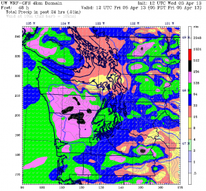
We may flirt with mild temperatures one last time tomorrow as a warm front approaches, but the dry weather will quickly be history—drowned out by a springtime soaking of half an inch. The rain should be heaviest during the late afternoon and early evening hours, tapering off to some degree after sunset. Windy conditions will also pick up later in the day, especially north and west of Everett, as an area of low pressure churns toward Vancouver Island.
Another shot of rain arrives Friday morning, followed by somewhat drier conditions around noontime as the bulk of the moisture hangs up over the mountains. A cold upper level low diving into the Northwest late Friday into Saturday will bring the showers back—along with chillier temperatures. Highs on Saturday are only expected to reach the mid 50s, with low temperatures sinking near 40. On the bright side, things should turn partly sunny by the afternoon.
Sunday will also feature plenty of clearing, although with the mercury stuck in the 50s, it won’t be nearly as spring-like as last Sunday. Still, the day should wind up dry—which would actually make it our fourth rain-free Sunday in a row.
Hey, there’s one good thing that hasn’t wrapped up yet.


