April 1991 can breathe easy now.
A spring storm blowing into the region late tonight and Monday morning will douse Seattle with another round of rain—but it won’t be enough for this month to overtake the record 6.53 inches that fell 22 years ago in Seattle’s wettest April.
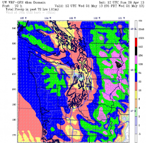
Our monthly rain tally currently sits at a soggy 5.71 inches—the second-highest amount ever observed during April in the history of Sea-Tac Airport. However, we’ll need nearly an inch more to unseat April 1991 from the top of the chart—and forecast models are insistent that no more than half an inch will land in the rain gauge before April wraps up.
The bulk of the moisture sweeps into the region late this evening, between 8 p.m. and midnight, just ahead of a fast-moving cold front that will zip into the Cascades early Monday morning. Temperatures, which dipped below normal this weekend in the wake of our recent warm spell, will crash into the mid 40s overnight amid overcast skies. Overall, most areas should collect up to a quarter-inch of rain by sunrise, with the North Seattle-to-Everett corridor seeing markedly less thanks to the Olympic rain shadow.

We’ll add more to this total during the day on Monday as a hefty Puget Sound Convergence Zone sets up shop, first over Snohomish County and then down into King County by the lunch hour. The heaviest of the rain should stay north of I-90 and east of 405, but intermittent showers will boost Seattle’s total by another tenth of an inch or so. At Sea-Tac, April rainfall should reach 6 inches during the afternoon—but it won’t climb much higher before the faucet shuts off.
With ample cloud cover and a cooler air mass in place, high temperatures tomorrow will only top out in the mid 50s—a good five degrees below normal. Lows will drop into the upper 30s early Tuesday morning, before increasing sunshine warms us back to near 60 degrees. With no additional rainfall expected in Seattle, the month will finish second on the list of the city’s wettest Aprils, much to the delight of the deeply exhaling April 1991.
May kicks off bright and sunny, with a strengthening area of high pressure over the ocean catapulting temperatures into the upper 60s by Wednesday afternoon. As the ridge scoots even closer and warmer air funnels into the region, the mercury should creep past 70 degrees on Thursday, possibly soaring into the—take a deep breath—upper 70s in time for Friday.
Up first, though, is another batch of wet weather—so take a cue from April 1991 and kill the hyperventilating, at least for now.


