It’s the beginning of the end.
Our nearly week-long stretch of pleasant weather, which saw high temperatures jump from the upper 50s to within a hair of 70—Sea-Tac hit 69 degrees yesterday—will slowly wind to a close tonight as cooler air begins trickling in. By mid-evening, a fresh slate of clouds from the Pacific will also overspread the region, stamping out the rest of our sunshine and setting us up for some overnight rain.
Thankfully, most of the moisture that falls late tonight into early tomorrow will be on the lighter side, with just dribs and drabs around the Sound. Slightly higher totals are possible further east near the foothills, but even there, amounts should stay under a tenth of an inch.

We dry off in time for the morning commute tomorrow, with cool, mostly cloudy conditions taking hold. By early afternoon, though, a round of heavier showers swings in from the coast, unleashing up to a quarter-inch of rain on the metro area. Under damp skies, highs will struggle to make it out of the 50s.
The rain fades away Wednesday morning, with the sun poking a few holes in the overcast later in the day. By and large, though, the day will trend mainly cloudy, with peak readings staying in the upper 50s.
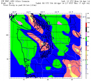
On Thursday, a cold front sweeps in from the northwest, ushering in a bigger soaking—Seattle can expect half an inch of rain by nightfall. Further north, three-quarters of an inch could land in local rain gauges—making for the region’s biggest downpour since March.
Fortunately, things calm down in a hurry on Friday, with just a few lingering showers—mixed in with a dose of afternoon sun. Temperatures should also warm a notch or two, easing into the lower 60s by early evening. Rain chances then stay low through Saturday, with partly cloudy skies settling in by the time the day wraps up.
The end of the beginning—of another decent round of weather?
One can hope, right?


