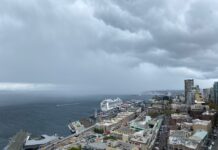
After a dry day on Sunday—rumor has it the sun even managed to peek through the overcast skies yesterday afternoon—the rain has returned for today.
Currently, light-to-moderate rain is falling across Puget Sound. As we work our way into the evening hours, that rain will continue to increase, becoming heavy after midnight. Then, just as tomorrow morning’s commute gets underway, a seemingly magical act will take place. The winds up high will shift to the west—and the rain will shut off completely.
All hail the Olympic rain shadow.

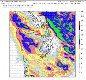
The infamous shadow, usually responsible for keeping places like Sequim and Port Angeles dry while the rest of Western Washington soaks, will shift further south and east tomorrow. This means that the entire Seattle-Everett-Tacoma metro area will largely skate by high and dry on Tuesday, while steady rains fall on areas to the north, south and east. In fact, some of the expected rainfall over these areas tomorrow could be quite heavy—current models project five-plus inches of rain in the mountains and foothills by Wednesday afternoon. (In response, the National Weather Service has issued a Flood Watch for all the rivers flowing off the western slopes of the Cascades.) Contrast that with the Seattle metro area, which will be lucky to get five-tenths of an inch of rain by the time Wednesday rolls around.
Despite the dry skies forecast for tomorrow, our weather won’t exactly be calm, as gusty winds are expected to pick up later in the morning. By afternoon time, the winds will really be roaring—with gusts above 40 mph possible near the water. The winds will gradually subside Tuesday night, with much lighter breezes on Wednesday. The heavy rain in the mountains will also die down on Wednesday, and by Thursday, the entire western half of the state should be dry.
Rain will return again on Friday, and continue on and off into the weekend. In addition, it’ll be accompanied by some much colder air—possibly cold enough to touch off some snow showers across the lowlands later on Saturday and on into Sunday. At this point, it goes without saying that a great deal of uncertainty still exists regarding exactly how cold it’ll get across Western Washington, how much moisture we’ll have to work with, and so on. Suffice it to say that this weekend will present the greatest threat for accumulating snowfall in the Seattle area since mid-January.
Stay tuned as we get closer.


