
Good news: The target sign is coming down soon.
Bad news: The rain will zero in on us again before it’s removed.
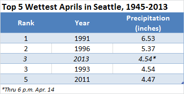
Another juicy system is set to roll through Western Washington tomorrow and Friday—the latest in a series of fronts that have made Seattle a bullseye for rain recently. Already, this month is the city’s third-wettest April on record, with only five days escaping measurable rainfall—two of which still recorded a trace. Fortunately, this storm looks to be our last for a while—but it’ll still pack quite a punch.
The parting shot begins early tomorrow as a warm front skips past the coast, eking out a round of showers just in time for the morning commute. The rain shouldn’t amount to anything too significant, but it’ll be a nuisance nonetheless. On the plus side, the gray skies will make for a warmer start to the day, with the mercury creeping into the mid 40s by sunrise.
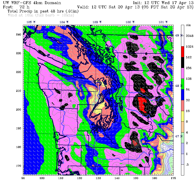
A break in the action is likely around lunchtime, before more moderate rainfall spreads back in during the afternoon. As a strong cold front races toward us from the west, the rain should pick up further in intensity, becoming heavy at times late tomorrow and early Friday. Totals with this system will top out near half an inch in the city, with places east of Lake Washington collecting a little more.
At Sea-Tac Airport, 0.83 inches of rain is needed for the month to knock April 1996 from second place on the list of Seattle’s all-time wettest Aprils—an amount that we’ll probably fall short of. However, a Puget Sound Convergence Zone forming behind Friday’s cold front will deliver another round of soaking rain wherever it sets up—and it if happens to be near the airport, 1996 may need to surrender its second-place trophy.
By Friday afternoon, the rain should be over for most places, but with a cold breeze settling in, the day will close on a raw note. Highs will only manage the mid 50s under overcast skies.
Things improve noticeably on Saturday, with just a few showers lurking in the Convergence Zone and spots near the foothills. Elsewhere, conditions will trend toward partly sunny, with temperatures warming a degree or two.
It’s Sunday when we finally lose the target sign. A building ridge of high pressure over the Pacific will inch close enough to kill off any remaining showers, leading to sunshine and highs near 60 degrees. By early next week, the ridge slides directly over the Northwest—sending the mercury soaring into the upper 60s and giving us our first extended run of dry weather since the beginning of the month.
Before Mother Nature put a bullseye our backs.


