The first half of November has been rather tame for the Seattle area, with most days featuring little rain, and almost no wind (with the noteworthy exception of last Friday).
In fact, through yesterday, SeaTac Airport has only received 0.91″ of rain in November–a far cry from the Nov. 1-14 average of 2.57′”. Our wettest day of the month so far? Nov. 2, when a measly 0.35″ rain fell from the skies. What is this, Phoenix?
 |
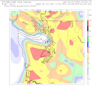
| NAM computer model showing the heaviest rain moving through Seattle around 2 p.m. |
The second half of November will try to buck this pathetic trend right out of the gate, giving us a solid rain by 9 a.m. tomorrow. Unlike Friday’s system, tomorrow’s rain will be coming at us from the southwest, meaning that our chilly temperatures should abate to some degree, as warmer winds kick up the mercury a notch. Highs tomorrow should be in the low 50s, but it’ll probably feel even warmer, thanks to winds that could gust as high as 40 mph around the metro area.
Right now, the National Weather Service is holding off on a Wind Advisory for the greater King-Snohomish-Pierce County region, but don’t be surprised if one is hoisted by tomorrow morning. The strongest winds for Seattle won’t actually come until late afternoon, with the passage of a strong cold front that will kick off another Puget Sound Convergence Zone up around Everett and points east. In any case, tomorrow evening will be quite blustery for most folks.
Look for heavier bands of showers to rotate through tomorrow night, before we start to dry out on Thursday. Temperatures, as promised, will fall into the lower 40s for Friday and Saturday, meaning that a rain/snow mix is possible in some of the heavier showers, especially in the Convergence Zone and areas away from the city. Right now, the National Weather Service is predicting a snow level of about 500 feet for both of these days, meaning that any snow accumulation is highly unlikely for the metro area.
Regardless, the coming weekend sure looks cold–with high temperatures in the upper 30s to low 40s, and lows in the upper 20s. If you can’t stand the “cold,” no worries, as a much warmer system is on tap to move into Western Washington Monday morning, flooding the region with our good ol’ marine air.
Until then, button up and hold on to that umbrella, especially tomorrow night!


