Less than five days and over 2 inches to go.
Can Seattle reach its average January rainfall by the end of the month?
Today marks the fifth day of rain in Seattle—following a near-record stretch of 12 dry days that ended with .20 inches of precipitation last Thursday. Since the wet weather returned, we’ve logged .67 inches as of noon today—an impressive amount if it were April or June, but a ho-hum total by January’s soggy standards. Still, it’s been enough to raise the month’s rainfall tally to 3.38 inches, giving us an outside chance of matching the January average of 5.57 before the calendar flips to February.
With mainly light rain expected for the duration of the day, we won’t add much to our total today—perhaps another .20 inches or so. The rain should pick up a notch or two in intensity around 7 p.m. tonight, before tapering back to light showers by midnight. Temperatures will remain steady in the low to mid 40s, only falling slightly as night sets in.

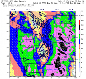
After a break in the action early tomorrow, another front will plow through the area by mid-morning, dampening the skies over Puget Sound once more. Rainfall with this system is likely to start out on the light side, before becoming heavier in the late afternoon hours. By Monday night, a widespread steady rain should be falling across the entire metro area, with amounts near half an inch. East of Lake Washington, it’ll be even wetter—expect rainfall totals around .75 inches.
Fresh off the heels of Monday’s system, rain spreads back into Seattle around sunrise on Tuesday and persists for much of the day. A good soaking is possible once again for the region, with amounts as high as an inch east of the I-405 corridor. Closer to Seattle, the rain should add up to half an inch, with high temperatures rising to the upper 40s.
We dry out considerably on Wednesday and Thursday, with just scattered showers at times. If the latest weather models are correct, we’ll have picked up roughly 1.5 additional inches of rain by the end of the 31st, putting January’s total just under five inches—still a good half-inch shy of normal. Of course, if tomorrow and Tuesday turn out to be wetter than expected, we could close in on the monthly average of 5.57 inches—but odds are that January will go down as our first drier-than-normal month since last September.
After such a wet fall, it’s about time the pendulum swung the other way.
Interested in how much rain we had last year—or any year since 1948? Curious when the city’s snowiest winters were? Check out the new charts on yearly rain and snow in Seattle.


